Overview of Ireland’s Geographical Position
Ireland, often referred to as the Emerald Isle, is a land steeped in myth and history, its landscapes shaped by both natural forces and the hands of its ancient inhabitants. To understand the intricate web of trade networks that emerged in Ireland’s prehistory, one must first appreciate its geographical position. Nestled in the North Atlantic, Ireland is separated from Great Britain by the narrow waters of the Irish Sea and is flanked by the Atlantic Ocean to the west. This unique location has played a pivotal role in shaping the island’s cultural and economic exchanges throughout history.
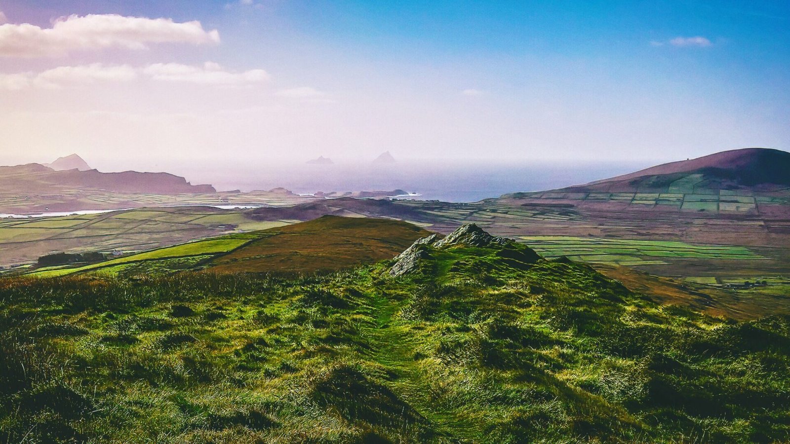
Geographic Features
Ireland is characterized by a diverse range of geographical features, from its rugged coastlines and rolling hills to its expansive plains and tranquil lakes. The island measures approximately 486 kilometers (about 302 miles) from north to south and 275 kilometers (about 171 miles) from east to west, making it the third-largest island in Europe. Its topography is dominated by a central mountain range, the Macgillycuddy’s Reeks, which includes the highest peak, Carrauntoohil, standing at 1,038 meters (3,406 feet).
The island’s coastline stretches over 7,500 kilometers (about 4,660 miles), punctuated by dramatic cliffs, sandy beaches, and sheltered bays. The Wild Atlantic Way, a scenic coastal route, showcases the stunning beauty of Ireland’s western seaboard, where the Atlantic Ocean crashes against the land, creating a dynamic and ever-changing landscape. This extensive coastline not only offers breathtaking views but also serves as a vital resource for trade and exploration.
Climate and Natural Resources
Ireland’s temperate maritime climate, characterized by mild winters and cool summers, has significantly influenced its agricultural practices and settlement patterns. The island receives abundant rainfall, which nourishes its lush green pastures and supports a rich biodiversity. This climate has historically allowed for the cultivation of crops such as barley, oats, and wheat, as well as the grazing of livestock, particularly sheep and cattle.
The natural resources of Ireland have also played a crucial role in its trade networks. The presence of fertile land, coupled with an abundance of fish in its surrounding waters, enabled early communities to establish sustainable agricultural and fishing practices. Additionally, Ireland is rich in minerals, including copper, lead, and gold, which were highly sought after in ancient trade. The extraction and trade of these resources facilitated connections with neighboring regions, contributing to the development of complex trade networks.
Strategic Location
Ireland’s geographical position at the crossroads of Europe and North America has made it a strategic hub for trade and cultural exchange. The island’s proximity to the British Isles and mainland Europe allowed for the movement of goods, ideas, and people across the waters. During prehistoric times, this strategic location facilitated contact with various cultures, including the Celts, who brought their own traditions and practices to the island.
The navigable waters surrounding Ireland, including the Shannon River, the longest river in the country, provided essential routes for trade and transportation. The river served as a vital artery for the movement of goods and people, connecting inland communities with coastal ports. This interconnectedness fostered a sense of unity among disparate groups and laid the groundwork for the complex social structures that would emerge in Ireland’s prehistoric landscape.
Trade Networks and Cultural Exchange
The geographical position of Ireland not only influenced its natural resources but also shaped its trade networks and cultural exchanges. The island’s early inhabitants engaged in trade with neighboring regions, exchanging goods such as textiles, pottery, and metalwork. These exchanges were not merely economic; they also facilitated the sharing of ideas, beliefs, and artistic practices.
Archaeological evidence suggests that Ireland was part of a broader trade network that extended to Britain, continental Europe, and beyond. The introduction of new technologies, such as metalworking and pottery techniques, can be traced back to these interactions. The arrival of the Celts, for instance, brought with it a wealth of knowledge about metalworking, which significantly advanced Ireland’s craftsmanship and artistic expression.
The influence of trade networks is also evident in the rich tapestry of Irish mythology and folklore. Many myths and legends reflect the interactions between different cultures, illustrating how trade and cultural exchange shaped the island’s identity. The stories of legendary figures, such as Cú Chulainn and the Tuatha Dé Danann, often intertwine with the landscape, emphasizing the deep connection between geography, culture, and mythology.
The Role of the Sea
The surrounding seas have historically played a crucial role in Ireland’s trade networks. The Atlantic Ocean served as a conduit for maritime trade, connecting Ireland with distant lands. The Vikings, for example, were known for their seafaring prowess and established trade routes that linked Ireland with Scandinavia and beyond. Their presence in Ireland led to the establishment of coastal settlements, such as Dublin, which became a thriving center of commerce and cultural exchange.
The sea also provided a rich source of sustenance for Ireland’s inhabitants. Fishing was a vital industry, with communities relying on the bountiful waters for their livelihoods. The abundance of fish, shellfish, and other marine resources not only supported local economies but also facilitated trade with neighboring regions. The coastal towns and villages became hubs of activity, where goods were exchanged, and cultural practices were shared.
The Influence of Landscape on Trade
The varied landscape of Ireland has also influenced its trade networks and settlement patterns. The presence of mountains, rivers, and fertile plains has shaped the movement of people and goods across the island. The central mountain range, for instance, acted as a natural barrier, influencing the routes taken by traders and travelers. The valleys and lowlands, on the other hand, provided fertile ground for agriculture, encouraging settlement in these areas.
The interplay between landscape and trade is further exemplified by the ancient stone structures and burial mounds scattered across the island. These monuments, often located in strategic positions, served as markers for trade routes and gathering places for communities. They reflect the deep connection between the land and its inhabitants, highlighting how geography has shaped both trade and cultural practices throughout Ireland’s history.
Conclusion
Ireland’s geographical position, with its diverse landscapes, strategic location, and rich natural resources, has played a fundamental role in shaping the island’s trade networks and cultural exchanges throughout prehistory. The interplay between geography and human activity has fostered a unique identity that is deeply intertwined with the myths and legends of the land. Understanding this geographical context is essential for appreciating the complexities of Ireland’s past and the enduring legacy of its trade networks. As we delve deeper into the connections between trade, mythology, and landscape, we uncover the intricate tapestry that defines Ireland’s rich heritage.